D1 - Nationally designated protected areas of the Republic of Armenia
What progress has been made with regard to the national designation of protected areas as a tool for biodiversity conservation?
Figure 1 - Change in the number and size of nationally designated protected areas in the Republic of Armenia (1990-2017)
Note: Since 2012, Armenia has been designating Natural Monuments (IUCN category III) in its nationally desginated protected areas system, which affected the immediate increase in the number of nationally desginated areas of the country
Data sources:
(D1)Main indicators specially protected areas by categories and years provided by the ArmStat – The Statistical Committee of the Republic of Armenia
Figure 2- Share of protected areas of the territory of the Republic of Armenia (2018)
Note: Protected areas calculation includes both nationally designated areas and the Emerald sites
Data sources:
(D1)Main indicators specially protected areas by categories and years provided by the ArmStat – The Statistical Committee of the Republic of Armenia
Roekaerts, M. and Opermanis, O., 2018. Status of the Emerald Network of Areas of Special Conservation Interest in 2018, Group of Experts on Protected Areas and Ecological Networks 9th Meeting, T-PVS/PA (2018) 11, Council of Europe, Strasbourg. (accessed 15 March 2019)
Armenia is a typical mountainous country, where the landscapes and ecosystems form a complex multi-functional system. Given the geographical features of the territory and the climatic conditions, the coutry has various ecosystem types, such as steppe, forest, mountain-meadow and water landscapes, the specific conditions of which have generated a rich variety of habitats for plant and animal species, unique symbiosis, a high level of endemism and rich agrobiodiversity. The abundance of species in Armenia is also conditioned by the fact that Armenia is located in the intersection of important provinces of flora and fauna in the region, as well as being a crossroad on birds’ migration routes. As a result, in the small territory of the country (about 2,974,300 ha) there are about 3 800 species of vascular plants, 428 species of soil and water algae, 399 species of mosses, 4 207 species of fungi, 464 species of lichens, 549 species of vertebrates and about 17 200 species of invertebrates.
Biodiversity conservation in Armenia is implemented mainly by establishing specially protected areas, where 60-70 % of the species composition of the flora and fauna is concentrated, including the overwhelming majority of rare, critically endangered, threatened and endemic species.
Analyses of the coverage of protected areas by ecosystem types show that protected areas are mostly covered by water landscapes (127 254.08 ha or 4.5 % of the total area of Armenia, 9 % of the protected areas system) but the majority of it falls on Lake Sevan (124 759.0 ha). Forest landscapes cover 110 269.2 ha or 3.9 % of the total area of Armenia, and mountain-meadow landscapes cover 87 516.24 ha or 3.07 % of the total area of Armenia, of which 22.6 % falls in nationally designated protected areas. Similarly, steppe landscapes occupy 61 391.7 ha or 2.2 % of the total area of Armenia and 15.8 % of them are under protection. Semi-desert landscapes cover only 623.14 ha or 0.02 % of the total area of Armenia, which are located within the existing protected area system of the country.
Armenia has made substantial progress in designating protected sites since 2009. The total area of nationally designated protected areas currently covers 12.90 % of the terrestrial territory and inland waters of Armenia. However, still some efforts are needed to reach at the Aichi biodiversity target11, which aims to have 17 % of terrestrial and inland water areas under the protected area system by 2020. Armenia has also made substantial progress in designating sites to be included into the Emerald network. Total protected area as candidate to the Emerald network reached to 34.8 % of the country territory in 2017.
Despite all efforts, the designation of protected areas is not solely a guarantee of biodiversity protection. Therefore, beyond this quantitative analysis, specific information on site management and quality would help to complete the assessment on Aichi biodiversity target 11 of the Convention on Biological Diversity (UN, 1992).
Figure 3 - Progress in protected areas by nationally designated types in Armenia (1959-2018)
Data sources:
(D1)Main indicators specially protected areas by categories and years provided by the ArmStat – The Statistical Committee of the Republic of Armenia
Overall, protected areas are implemented under four different national desginations: (1) state reserves (Khosrov, Shikahogh and Erebuni); (2) national parks (Sevan, Dilijan, Lake Arpi and Arevik); (3) state preserves (a total of 27 state preserves); and (4) natural monuments (a total of 232 natural monuments).
A number of legal acts on flora and fauna, forests and protected areas have been developed and adopted with the aim of ensuring biodiversity conservation and sustainable use in the country. In addition, an action plan for implementing the programme of work on protected areas of the Convention on Biological Diversity, 2012-2020, has also been developed with the following priorities: establishing and strengthening national and regional systems of protected areas and developing site-level management plans for state-owned reservations (MNP, 2012).
The period 2009-2014 was a breakthrough in the designation of national protected areas. Since then the focus has been mainly on the establishment of state preserves and national parks. In that context, Dilijan State Reserve has been developed as a national park, and the territorial share of the national parks in the nationally designated protected areas has been substantially increased.
Protected areas are state property and are managed by state organisations. In Armenia the management of protected areas is carried out by the Bioresources Management Agency of the Ministry of Nature Protection of the Republic of Armenia, Agriculture Scientific Centre of the Ministry of Agriculture of the Republic of Armenia and the A. I. Alikhanyan National Scientific Laboratory (the Yerevan Institute of Physics). However, the natural monuments, which are located on both state and community property, are still not properly managed due to the absence of respective management mechanisms (MNP, 2012).
On the other hand, the administrative organisation of some particular protected areas has also been modified in accordance with the needs of particular protected areas. For instance, the charter of Sevan National Park and the Managing Council of the Sevan National Park State Non-commercial Organisation was established and is chaired by Armenia’s Deputy Prime Minister. The main objective of the Council is to improve and strengthen control of the restoration of ecosystems of Lake Sevan and its littoral areas, as well as to make the process of national park-related decision-making more transparent (MNP,2014).
Figure 4 - Nationally designated protected areas by International Union for Conservation of Nature (IUCN) management categories (1990-2017)
Data sources:
(D1)Main indicators specially protected areas by categories and years provided by the ArmStat – The Statistical Committee of the Republic of Armenia
Aligment of nationally desginated areas according to the International Union for the Conservation of Nature and Natural Resources (IUCN) management categories is more site specific. In that context, the majority of protected areas falls into the national park area (category II) and habitat/species management area (category IV) of the IUCN.
Figure 5 - The spatial complementarity between European desgination (Emerald Network- candidate site) and national desginations by share of terrestrial area (2018)
Data sources:
- (D1)Main indicators specially protected areas by categories and years provided by the ArmStat – The Statistical Committee of the Republic of Armenia
- Data on Emerald sites provided by the Ministry of Environment (formerly the Ministry of Nature Protection) of Armenia under the ENI SEIS II East project activities
- Roekaerts, M. and Opermanis, O., 2018. Status of the Emerald Network of Areas of Special Conservation Interest in 2018, Group of Experts on Protected Areas and Ecological Networks 9th Meeting, T-PVS/PA (2018) 11, Council of Europe, Strasbourg. (accessed 15 March 2019)
The nationally designated protected area system and the Emerald Network under the Bern Convention represent the two most important coordinated European networks of protected areas. The degree of overlap between nationally protected areas and Emerald sites (candidate or formally adopted sites) illustrates the extent to which a country has made use of nationally designated areas to underpin its Emerald designation and to what extent Emerald sites extend beyond national systems. In Armenia, according to the available data, there is not spatial overlap in the designation between protected areas and the proposed sites to Emerald network and each designation type is established seperately.
The establishment of the Emerald Network started during 2007-2008 as part of the introduction of the Emerald Network programme in Armenia, according to the defined target of 10 % of sites to be included in the Emerald Network. The programme has resulted with proposing some areas to be included into the Emerald network such as Khosrov Forest, Sevan, Lake Arpi, Khor Virap, Plane grove, Khustup, Erakhi range, Lori lake and Sjuniqi shibljak. The database and geographic information system (GIS) maps also have been developed for these areas. In 2013, the Khosrov Forest State Reserve was granted a European diploma by a special decision of the Committee of Ministers of Europe (Council of Europe, 2013).
Currently, a total of 23 sites are in “candidate” status to the Emerald Network, consisting of 1 033 719.7ha and corresponding to 34.8 % of the country’s territory (Roeakaerts and Opermanis, 2018). The development of the Emerald Network is a first step towards the creation of an ecological network in Armenia, provisioned by the Law on the specially protected nature areas of the Republic of Armenia. It is also a part of a national policy for joining international networks such as the Pan European Ecological Network (Council of Europe, 1979). There is no any site from Armenia in the list of adopted sites of the Emerald network yet (status of November 2019).
In addition, Armenia is actively engaged in a number of international designations such as the pan-European biological and landscape diversity strategy, and the Ramsar Convention and the Bonn Convention, regarding important bird areas.
Figure 6 - Nationally designated protected areas of the Republic of Armenia (2018)
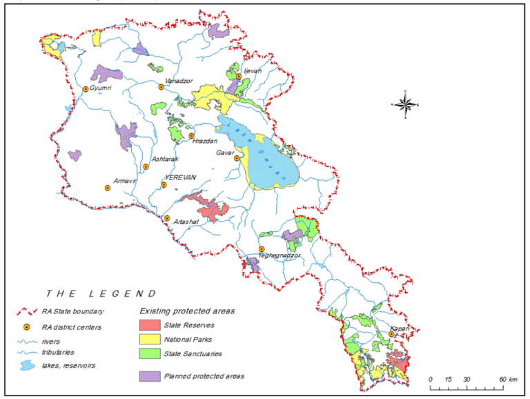
Data sources:
Ministry of Nature Protection of Republic of Armenia, 2014. Strategy and state program of conservation and use of specially protected nature areas of the Republic of Armenia. Government decree N 1059-Ա, September 25, 2014, Yerevan.
Indicator specification
Indicator definition
The proposed definition is a combination of the D1 UNECE Environmental Indicator and of the Streamlined European Biodiversity Indicators (SEBI) 007 indicator.
The indicator shows the terrestrial area protected in compliance with the national legislation and its development over time. It reflects both the extent of protected areas and their share in the total area of the country.
The indicator can be further broken down by IUCN management categories and by category of national designation (national park, strict nature reserve, protected landscape etc.). In addition, a sub-indicator showing the relation between nationally designated areas at national level and areas designated as Emerald sites can be developed.
Units
Area (ha) of nationally protected areas as a percentage of the country territory.
Rationale
Justification for indicator selection
Establishment of protected areas is a direct response to concerns over biodiversity loss, so an indicator of protected area coverage is a valuable indication of commitment to conserving biodiversity and reducing loss at a range of levels.
The indicator demonstrates the change over time in one form of protection afforded to components of biodiversity. It provides a measure of the response to the degradation of ecosystems and the loss of biodiversity in a country. It demonstrates the extent to which areas important for conserving biodiversity, cultural heritage, scientific research (including baseline monitoring of processes in the ecosystems), recreation, natural resource maintenance and other environmental values are protected.
This indicator is also a measure of the distance to the global target, i.e. the Aichi biodiversity target and shows the national contribution to the global network of protected areas.
Scientific references
-
Council of Europe, 2013. Adopted Resolutions on the award and the renewal of the European Diploma of Protected Areas in 2013, Resolution CM/ResDip(2013)2 on the award of the European Diploma of Protected Areas to the Khosrov Forest Reserve (Armenia), Strasbourg.
-
Dudley, N., (Editor), 2008. Guidelines for Applying Protected Area Management Categories. Gland, Switzerland: IUCN. x + 86pp. WITH Stolton, S., P. Shadie and N. Dudley (2013). IUCN WCPA Best Practice Guidance on Recognising Protected Areas and Assigning Management Categories and Governance Types, Best Practice Protected Area Guidelines Series No. 21, Gland, Switzerland: IUCN. xxpp. 978-2-8317-1636-7
-
MNP, 2012. Action Plan for Implementing the Programme of Work on Protected Areas of the Convention on Biological Diversity — Armenia, Bio resources Management Agency of the Ministry of Nature Protection of the Republic of Armenia, Report to CBD secretariat ( accessed 18 March 2019).
-
Roekaerts, M. and Opermanis, O., 2018. Status of the Emerald Network of Areas of Special Conservation Interest in 2018, Group of Experts on Protected Areas and Ecological Networks 9th Meeting, T-PVS/PA (2018) 11, Council of Europe, Strasbourg. (accessed 15 March 2019)
Policy context and targets
Context description
National policy context
This indicator measures how much Armenia is contributing to protecting special protection areas on national, regional and global scales. It can assist in monitoring the efficiency of national policy and strategic development in the protected areas system of Armenia.
The action plan for implementing the programme of work on protected areas of the Convention on Biological Diversity 2012-2020 (the 25.09.2014 N1059-A Government decision) specifies the establishment and strengthening of national and regional systems of protected areas integrated into a global network as a contribution to globally agreed goals.
International policy context
The United Nations Convention on Biological Diversity aimed at the establishment and maintenance of comprehensive, effectively managed and ecologically representative national and regional systems of protected areas.
Targets
National targets
No target has been specified.
International targets
Under the CBD, the strategic plan for biodiversity 2011-2020 was adopted, which requires that, by 2020, at least 17 % of terrestrial and inland water areas, and 10 % of coastal and marine areas, especially areas of particular importance for biodiversity and ecosystem services, are conserved through effectively and equitably managed, ecologically representative and well-connected systems of protected areas and other effective area-based conservation measures, and integrated into the wider landscapes and seascapes (Aichi biodiversity target 11).
Related policy documents
-
Aichi Biodiversity Targets of the Convention on Biological Diversity. UN CBD, 2011. Strategic plan 2011-2020.
-
Action Plan for Implementing the Programme of Work on Protected Areas of the Convention on Biological Diversity-Armenia. Ministry of Nature Protection of the Republic of Armenia, 2012. Bio resources Management Agency of the Ministry of Nature Protection of the Republic of Armenia, Report to CBD secretariat.
-
Convention on Biological Diversity. United Nations, 1992.
-
Law on Specially Protected Nature Areas. Government of the Republic of Armenia, 2006 (no online link has been provided).
-
Strategy and state program of conservation and use of specially protected nature areas of the Republic of Armenia. Ministry of Nature Protection of Republic of Armenia, 2014. Government decree N 1059-Ա, September 25, 2014, Yerevan.
Methodology
Methodology for indicator calculation
It is necessary for this indicator to have a database of all nationally protected areas in the country, including name of the protected area, date of establishment, protection regime in accordance with national legislation (and relevant international requirements), size and digital boundaries.
To break down results by IUCN management category, it is necessary for each protected area to be characterised according to the type of management applied, following the IUCN guidelines.
To assess the (spatial) complementarity between Emerald site designation and nationally protected areas, two datasets are necessary (to be overlaid): (1) spatial delineation of nationally protected areas; and (2) spatial delineation of Emerald sites (only candidate and officially designated Emerald sites to be considered).
The percentage of protected areas can be calculated by the formula:
Share of protected areas (%) = (total area of protected areas in hectares or km2/total area of the country in hectares or km2) × 100.
Protected area coverage can be calculated nationally and by sub-national administrative unit of terrestrial and/or marine area.
Methodology for gap filling
No methodology for gap filling has been specified.
Methodology references
-
In the Armenia context, the alignment of the nationally designated areas with the IUCN categories at the site level might be interpreted as the following:
a. Khosrov forest and Shikahogh and Erebuni reserves correspond to category I.
b. All existing four national parks of Armenia correspond to IUCN category II.
c. Nature monuments of Armenia correspond to category III.
d. Sanctuaries where species and their habitats are under specific conservation regimes
are in category IV.
e. Categories V and category VI are not applicable to Armenia.
-
Dudley, N. (Editor) (2008). Guidelines for Applying Protected Area Management Categories. Gland, Switzerland: IUCN. x + 86pp. WITH Stolton, S., P. Shadie and N. Dudley (2013). IUCN WCPA Best Practice Guidance on Recognising Protected Areas and Assigning Management Categories and Governance Types, Best Practice Protected Area Guidelines Series No. 21, Gland, Switzerland: IUCN. xxpp. 978-2-8317-1636-7
-
EEA, 2005. EEA core set of indicators guide. EEA Technical report No 1/2005, ISBN 92-9167-757-4, Luxembourg.
-
EEA, 2018. Nationally designated protected areas. CSI 008, SEBI 007.
-
UNECE, 2018. Guidelines for the Application of Environmental Indicators, Data template – D1. Protected areas.
-
UNECE, 2018. Guidelines for the Application of Environmental Indicators, Description of D1. Protected areas.
-
UNECE, 2018. Guidelines for the Application of Environmental Indicators, Glossary of terms – D1. Protected areas.
Uncertainties
Methodology uncertainty
The indicator ‘Progress in the designation of protected areas by IUCN categories over time’ could not be clearly defined, as many national protected areas may include a territory with several IUCN categories. A specific definition of the IUCN category is possible by a separate expert assessment.
Data sets uncertainty
The data set used in the indicator has large breaks in the time series. On the other hand, the procedure of data collection is not sufficiently clear. Therefore, the data in this indicator present high levels of uncertainty.
Rationale uncertainty
The indicator does not describe the quality of management or whether or not the areas are protected from incompatible uses. The indicator needs to be complemented by information on management effectiveness or funding or by other elements that would indicate the potential of the designated area to protect biodiversity.
Data sources
-
(D1)Main indicators specially protected areas by categories and years provided by the ArmStat – The Statistical Committee of the Republic of Armenia
-
Data on Emerald sites provided by the Ministry of Environment (formerly the Ministry of Nature Protection) of Armenia under the ENI SEIS II East project activities
-
Roekaerts, M. and Opermanis, O., 2018. Status of the Emerald Network of Areas of Special Conservation Interest in 2018, Group of Experts on Protected Areas and Ecological Networks 9th Meeting, T-PVS/PA (2018) 11, Council of Europe, Strasbourg. (accessed 15 March 2019)
-
World Bank, 2019. Land area (sq. km) database - Armenia