ENI SEIS II East project supports pilot project on Corine Land Cover maps: Absheron Peninsula
‘Pilots on extending the Corine Land Cover (CLC) methodology to areas of the partner countries’ is a step towards facilitating the access to, and use of, some spatial data required for implementing SEIS at national level. Azerbaijan has successfully implemented a national pilot project using the CLC methodology in an area of 2 500 km² on the Absheron Peninsula, including the capital city of Baku and its outskirts.
At the country level the activity was coordinated by the Ministry of Ecology and Natural Resources, while technical implementation was realised by the company Geodesy and Cartography LLC. The pilot project applied CLC methodology to map the CLC status layer for 2018 and CLC changes for the period 2000-2018.
The Absheron Peninsula is the most developed industrial and urbanised region of Azerbaijan. Oil has been produced industrially for more than 150 years in the peninsula. For many years, wastes from the oil industry and its associated industries have led to pollution of some areas on the peninsula reaching ‘crisis level’. In recent years, important projects have been implemented to rehabilitate contaminated land.
The Absheron Peninsula has faced many changes in the last 18 years. Approximately, 10.6 % of the pilot area changed between 2000 and 2018. These changes include exceptional processes not common in other parts of Europe: transforming water bodies into an urban environment. Major parts of water bodies have been turned into, for example, residential and commercial areas, green urban areas and construction sites.
Major changes that identify the evolution processes in the pilot area were decreases in pastures and natural grassland areas and increases in areas of discontinuous urban fabric and irrigated arable lands.
- More than 25 % of the area saw increases in the following classes:
- ports, construction sites, sport and recreation areas, airports and dumpsites;
- agricultural plantations (vineyards, fruit trees, olives) and irrigated arable land.
- More than 25 % of the area saw decreases in the following classes:
- non-irrigated arable land and pastures;
- wetland (inland and coastal).
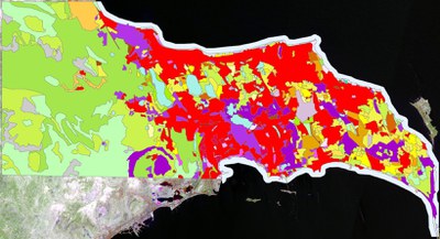
CLC 2018 Map of Absheron Peninsula pilot area