ENI SEIS II East project delivers Corine Land Cover pilot project in Armenia
© Ani Hambardzumyan
To understand recent changes in the Earth system, the scientific community and decision-makers need quantitative, spatially explicit data on how land cover has been changed by human use over recent years and how it will be changed in the near future. The Corine Land Cover (CLC) methodology provides policymakers with environmental data on land use and land cover for planning and management and to reconcile land use with environmental concerns.
Land is a finite resource: how it is used constitutes one of the principal drivers of environmental change and has significant impacts on ecosystems and quality of life. In extreme cases, such changes might lead to unhealthy and degraded land.
The pilot project on the CLC methodology in Armenia is a step towards facilitating access to and use of the spatial data required for SEIS implementation. This pilot allows direct links to programmes at the European level, namely the just completed update of the CLC2018 layers in the EEA’s 39 member and cooperating countries (as at 2018), and services provided through the Copernicus programme.
The CLC pilot project was implemented in Armenia by the national technical team (Geoinfo LLC, technical team coordinator Samvel Nahapetyan) with capacity development from the EEA. CLC mapping work was carried out in the pilot area (2 500 km2) selected and approved by the Ministry of Environment, based on a relevant nomination.
The work was carried out using European Space Agency (ESA) Sentinel-2 satellite images taken in 2018-2019 and based on the norms approved for CLC cartographic work. In CLC change mapping between 2000 and 2018, Landsat TM satellite images taken in 2000 were used. Digital maps of forest and protected areas were also used as a basis.
The information received is standardised, as the EEA’s member and cooperating countries have a total area of 5.8 million km2. The same kind of maps are produced in five ENI SEIS II East cooperating countries. If CLC mapping could be extended to the whole territory of Armenia for the period 2000-2018, it could have great practical significance in the following spheres.
Environmental sphere:
- revealing natural and anthropogenic changes in forests and specially protected areas;
- following the quantitative and qualitative changes in forest areas and landscapes;
- mapping changes in the boundaries of water bodies;
- mapping changes in natural green areas.
Agricultural sphere:
- quantitative statistical analysis and evaluation of spatial changes in perennial seedlings and vineyards;
- quantitative and qualitative analysis of changes in non-irrigated and irrigated agricultural land;
- monitoring changes in agricultural land between 2000 and 2018.
Urban development and territorial administration:
- following and statistically analysing areas of settlements under construction and the trends in and nature of their changes.
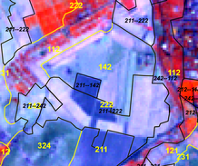
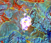
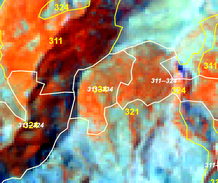
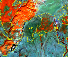
Some examples of changes (2000-2018)
Conversion of arable land (211) to orchards (222)

Conversion of pasture (231) to mining site (131)

Conversion of forest (311) to burnt area (334)