Water as a thematic area
Water has been identified by ENI East countries (Armenia, Azerbaijan, Belarus, Georgia, the Republic of Moldova and Ukraine) as one of the three thematic priorities for which the ENI SEIS II project should support the countries in collecting data, implementing indicators and undertaking the assessment for knowledge-based decision making in environmental management.
Water issues are serious and worsening in many parts of Europe including eastern Europe and Caucasus region. Many river basins in the Region has transboundary character which require effective cooperation and collaboration among countries and various sectorial players. Knowledge-based decision making is crucial for effective policy dialogue in water resources management. For that purpose, obtaining relevant, reliable, robust and harmonized water data, implementing the indicators to assess the state and pressure on water resources as well as undertaking the necessary assessment to provide the information needed for the policy making are crucially important.
What are the objectives of the water component in the ENI SEIS II East Project?
The water component of the project primarily aims at supporting ENI East countries gradually develop and extend their national portal of water information systems in line with the SEIS principles in terms of institutional cooperation, content and infrastructure. As a result, this should help Countries to better respond to international commitments, such as, reporting under the Sustainable Development Goals (SDGs), regional water conventions and also to support water resources management at the appropriate scale. In addition, by means of implementation of the indicators, the water component will support the countries to undertake knowledge-based assessment on water resources management.
What are the key tasks under the water component?
There are two major tasks;
a- Support the implementation of selected water indicators (quality and quantity) for underpinning regional commitments e.g. UNECE Environment for Europe Process, Joint Task Force on Environmental Statistics and Indicators etc
b- Further support the implementation of online data sharing among institutions and agencies, with the purpose of providing data, information and assessment needed in the State of Environmental Assessment (SoE) including other relevant national environmental policies.
Which indicators will be implemented?
Two major groups of indicators from the UNECE Regional Environmental Indicators will be implemented at the national level with the purpose of assessing water resources and quality. This will also help in nesting knowledge and experiences on developing geo-referenced indicators at river basin scale in the near future.
Here are the proposed indicators;
a- Water quality indicators;
C10. BOD and concentration of ammonium in rivers
b- Water quantity indicators;
C1. Renewable freshwater resources
C4. Household water use per capita
C5. Water supply industry and population connected to water supply industry
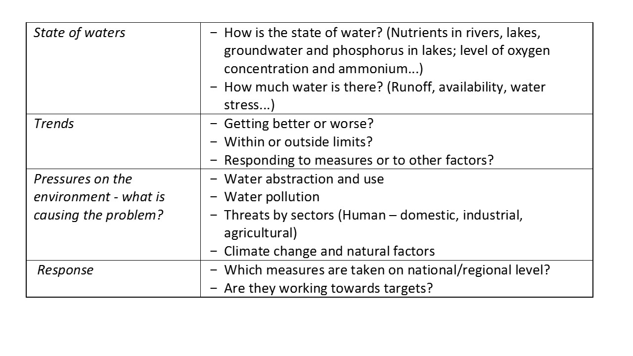
How do indicators help build a knowledge-base policy implementation in water resources management?
The selected indicators will provide information on key policy questions which might be put forward by decision makers in your country. Examples of key policy questions in relation to water indicators would be as the followings;
For further information on the implementation of the environmental indicators please visit to the report on Digest of EEA indicators
How are indicators implemented?
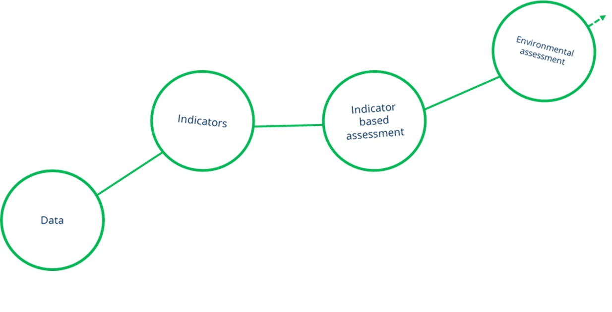
Implementing the indicators is a part of process from data to knowledge which is defined as MDIAK (Monitoring, Data, Information, Assessment and Knowledge) chain. In that context, indicators require to get a set of harmonized and integrated data to be processed in accordance with predefined methodological specifications (Figure 1). The first step is to prepare relevant, reliable, robust and harmonized data which might come from different agencies and ministries. The second step is to compute the indicator in line with agreed methodology. And the last step is to interpret objectively with the outputs of the indicator computation by following certain type of analytical frameworks such as DPSIR (Driving forces, Pressures, State, Impact and Response). The ENI SEIS II East project will provide hands-on training and helpdesk support throughout all three identified steps.
Figure 1: Work steps from data to the assessment
How are indicators used?
Indicators generally simplify in order to make complex phenomena quantifiable, so that the information can be communicated with the public at large. They also provide the basis for identification and assessment of environmental problems and the dominant threats at different levels e.g. local, regional or global. Indicators provide also information necessary to enable actions/policies to be taken to improve the environmental state of the water bodies and to ensure sustainable development.
For examples of the water quantity related indicators, click on the following link;
Use of freshwater resources — EIONET/European Environment Agency
For the water quality you can also see example on the following link;
Nutrients in freshwater – EIONET/European Environment Agency
From indicator production to its use: how to organise a shared water information system?
In general, an information system is an organized system for the collection, organization, storage and communication of data and information by means of required hardware-software combination under agreed data dictionary and inter-institutional data exchange protocols. An information system would have different sub-components ([1]) e.g.;
Information technology (IT)
- Hardware (server and other connected computers)
- Software (programs and codes based on chosen software technologies)
Data policy
- Interoperability framework – data exchange protocol
Metadata catalogue
- Standard data dictionary- harmonizing and sharing the data collected by different agencies
Content management
- Visualisation and sharing the data – web applications
The ENI SEIS II East project primarily aims to improve the capacity at the national level by sharing the EIONET expertise and knowledge with ENI East countries. In that context, development an information system for water would be supported for defining a standard data dictionary aligned with the European data reporting streams. EEA experts will also support development of the inter-institutional data exchange protocol in the countries. IT experts will also be trained and further be supported by a continued helpdesk until the end of 2018.
How to implement all?
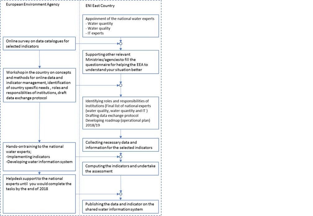
What is needed is to ensure effective cooperation, collaboration and team working between European Environment Agency and national institutions. The figure below is outlining the workflow (Figure 2).
Implementation phase
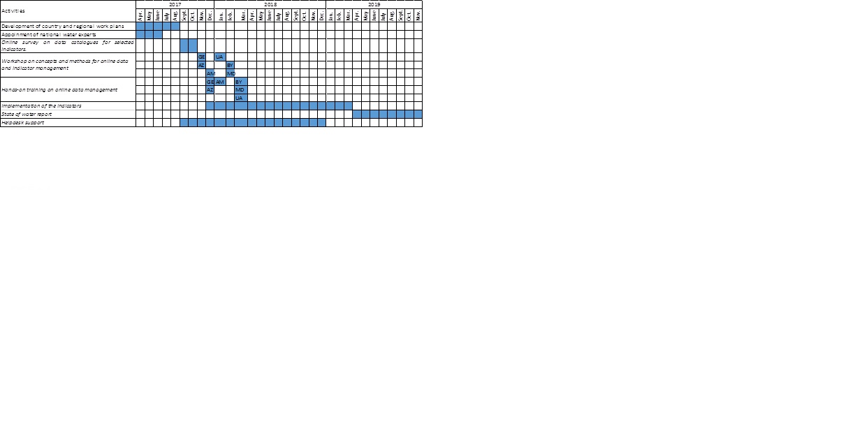
Note; the implementation phases are provisional and will be operational based on the feedbacks from the NFPs.
Survey on data catalogues for indicators of water quantity and quality
Contact point
Nihat Zal
Project Manager – Water, biodiversity, land
Tel: + 45 3336 7275
Fax: + 45 3336 7293
E-mail: Nihat.Zal@eea.europa.eu
European Environment Agency
Kongens Nytorv 6
DK-1050 Copenhagen K
Country contact points
[1] See the Water Information System for Europe as an example of data and knowledge platform; http://water.europa.eu/data-and-themes